Shawano County Unmarked Cemeteries LbNA #44619 (ARCHIVED)
| Owner: | Adoptable |
|---|---|
| Plant date: | Nov 20, 2008 |
| Location: | |
| City: | Shawano |
| County: | Shawano |
| State: | Wisconsin |
| Boxes: | 1 |
| Planted by: | gotta run |
|---|---|
| Found by: | Trekkin' and Birdin' |
| Last found: | Jun 19, 2010 |
| Status: | FFar |
| Last edited: | Nov 20, 2008 |
Finding this letterbox requires knowing how to work with latitude and longitude coordinates. You do not need a GPS receiver to find the letterbox (although it might make the search easier).
Years ago when traveling a few miles meant spending a day away from
home, burials were often performed on farms and homes. Over time,
some of those burial sites expanded and became public or church
cemeteries. However, some burial sites were simply forgotten over
time.
There are records for about 117 burial sites in Shawano County. The
large majority of those are marked cemeteries with signage and
public access where visitors are welcome.
However, there are 18 burial sites that are in backyards and woods.
The records of these sites are sketchy. Some can still be located,
but others are virtually lost to time.
YOU DO NOT NEED TO VISIT ANY OF THE LISTED REFERENCE POINT
COORDINATES. You are welcome to try to find these places on
your own if you wish, just as anyone pursuing genealogical or
historical interests would be. However, please be respectful of
private property and get permissions. Many of the coordinates are
"best-guestimates" or even dummy coordinates to mark the general
area. Read the descriptions for details.
Cemetery Information
Here are the cemeteries with the coordinates listed in degree
decimal format.
Adams Family Unmarked Graves
There are records of unmarked graves for the “two daughters of
Chris Adams.” The coordinates mark the approximate location
according to old plat maps..
45 00.46833
-89 06.67767
Bastil Family
There are records of a “private burial.” The coordinates mark the
approximate location according to old plat maps.
44 57.43281
-89 10.76230
Ehlert Burials
There are records of graves “on Ehlert land.” The exact location is
unknown and these coordinates mark a random point in the section
only.
44 48.23097
-89 00.68833
Frank Family
There are records of graves for the Frank Family. The coordinates
mark the approximate location according to old plat maps.
44 52.26919
-89 12.28381
Hahn Burial -
This is also known as Old town hall cemetery. There are no longer
any stones, and there are no markings for the cemetery. Coordinates
mark an approximate spot in the section according to old plat maps.
44 49.48110
-88 47.12266
Holms Family (unmarked/unknown)
There are records of “several burials behind the barn of Tom
Holms.” The location is unknown and these coordinates mark a random
spot in the section only.
44 36.97078
-88 29.57784
Kunzak
Also referred to as “Bielke” burials in the records. Coordinates
mark the approximate location.
44 53.05433
-88 59.53759
Lathrop
Little information on this burial; only the section is known and
the coordinates mark a reference point in the township section
only.
44 41.01037
-88 22.38613
Mailahn Cemetery
So named because the land was owned in 1898 by Charles Mailahn. The
cemetery is located south of the farmhouse and is very overgrown.
Many of the stones have fallen and are buried under roots. You may
freely visit the cemetery but it requires crossing active pastures
and navigating barbed and electric wire fence. Check at the
farmhouse first.
44 46.83398
-88 42.63138
Mietke Family
Approximate location.
44 47.93545
-88 43.80488
Reisenuber Burials
Approximate location in section only.
44 49.71996
-88 59.95432
Sander
Approximate location according to old plat maps.
44 46.68956
-88 46.02039
Sawyer Family (graves relocated)
This marks the approximate spot of the Sawyer Family burials. As
part of Indian Treaty negotiations, the graves in this cemetery
were relocated elsewhere and there is no longer a cemetery at the
location marked by the coordinates.
44 54.47819
-88 51.73125
Sheldon Family
This is a single stone burial. The remains of a home and farmstead
are on site. Check with the property owner before attempting.
44 41.54012
-88 35.21966
Unmarked Grave of Thomas Jefferson Lessor
For whom the township of Lessor is named after. Exact location of
the grave is unknown; coordinates mark only the approximate
location.
44 38.34090
-88 23.07758
Unnamed/Unmarked in Navarino
A grave is recorded in this section but the location is unknown.
Coordinates mark a random spot in the section.
44 35.84969
-88 29.39189
Weikel Family
The coordinates mark the approximate location according to old plat
maps.
44 53.49580
-89 01.70470
William Norton Home
In the records, this is recorded as “Two children buried behind the
William Norton Home on Old Lake Drive.” Ownership of the property
has long since changed. Approximate location.
44 49.54348
-88 34.19572
To find the letterbox:
Step 1:
Using the coordinates above, locate the SECTION number for the
burial sites shown below, then subtract the number as shown. In
order to find the section numbers, you'll have to find a way to map
the coordinates to a township/sectional map, and there are various
ways to do this. You might be able to find a detailed topo map on
your GPSr, you might find county township/sectional maps online
through one of the many mapping websites, or you can match up the
locations against hard copy township maps. Trust us, it can be
done, because we've done it. The trick is finding the right
resources, then it's pretty straightforward.
A = Mailahn Cemetery - 27
B = Ehlert - 16
C = Thomas Jefferson Lessor - 13
D = Unnamed/Unmarked in Navarino - 29
E = Hahn - 11
F = Lathrop - 33
G = Frank - 25
H = Sawyer Family - 10
I = Adams Family - 12
J = Kunzak - 16
Step 2:
Using the values you determined, the letterbox is located at N 44 AB.CDE/ W088.FG.HIJ. Note that these coordinates are in GPS format, NOT degree decimal. Use an online GPS mapping site to obtain a satellite image of the coordinate location. You will be able to find the letterbox based on that image. If you have a GPS receiver, that will make your search easier.
You can check your answers for this lettterbox
HERE.
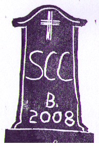
About Letterbox Hybrids
Letterbox hybrid caches contain a stamp for letterboxers but can also be found by geocachers. We're not really the artist type, but
here's what the stamp looks like:
Years ago when traveling a few miles meant spending a day away from
home, burials were often performed on farms and homes. Over time,
some of those burial sites expanded and became public or church
cemeteries. However, some burial sites were simply forgotten over
time.
There are records for about 117 burial sites in Shawano County. The
large majority of those are marked cemeteries with signage and
public access where visitors are welcome.
However, there are 18 burial sites that are in backyards and woods.
The records of these sites are sketchy. Some can still be located,
but others are virtually lost to time.
YOU DO NOT NEED TO VISIT ANY OF THE LISTED REFERENCE POINT
COORDINATES. You are welcome to try to find these places on
your own if you wish, just as anyone pursuing genealogical or
historical interests would be. However, please be respectful of
private property and get permissions. Many of the coordinates are
"best-guestimates" or even dummy coordinates to mark the general
area. Read the descriptions for details.
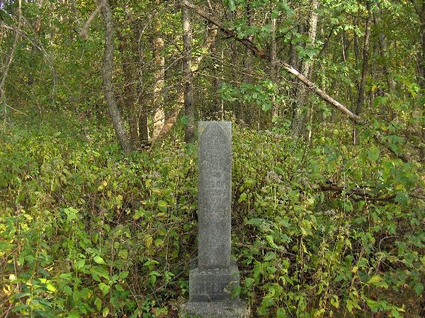
Photo at Sheldon Family Burial thanks to Lander &
Lancelot

Mailahn Cemetery
Cemetery Information
Here are the cemeteries with the coordinates listed in degree
decimal format.
Adams Family Unmarked Graves
There are records of unmarked graves for the “two daughters of
Chris Adams.” The coordinates mark the approximate location
according to old plat maps..
45 00.46833
-89 06.67767
Bastil Family
There are records of a “private burial.” The coordinates mark the
approximate location according to old plat maps.
44 57.43281
-89 10.76230
Ehlert Burials
There are records of graves “on Ehlert land.” The exact location is
unknown and these coordinates mark a random point in the section
only.
44 48.23097
-89 00.68833
Frank Family
There are records of graves for the Frank Family. The coordinates
mark the approximate location according to old plat maps.
44 52.26919
-89 12.28381
Hahn Burial -
This is also known as Old town hall cemetery. There are no longer
any stones, and there are no markings for the cemetery. Coordinates
mark an approximate spot in the section according to old plat maps.
44 49.48110
-88 47.12266
Holms Family (unmarked/unknown)
There are records of “several burials behind the barn of Tom
Holms.” The location is unknown and these coordinates mark a random
spot in the section only.
44 36.97078
-88 29.57784
Kunzak
Also referred to as “Bielke” burials in the records. Coordinates
mark the approximate location.
44 53.05433
-88 59.53759
Lathrop
Little information on this burial; only the section is known and
the coordinates mark a reference point in the township section
only.
44 41.01037
-88 22.38613
Mailahn Cemetery
So named because the land was owned in 1898 by Charles Mailahn. The
cemetery is located south of the farmhouse and is very overgrown.
Many of the stones have fallen and are buried under roots. You may
freely visit the cemetery but it requires crossing active pastures
and navigating barbed and electric wire fence. Check at the
farmhouse first.
44 46.83398
-88 42.63138
Mietke Family
Approximate location.
44 47.93545
-88 43.80488
Reisenuber Burials
Approximate location in section only.
44 49.71996
-88 59.95432
Sander
Approximate location according to old plat maps.
44 46.68956
-88 46.02039
Sawyer Family (graves relocated)
This marks the approximate spot of the Sawyer Family burials. As
part of Indian Treaty negotiations, the graves in this cemetery
were relocated elsewhere and there is no longer a cemetery at the
location marked by the coordinates.
44 54.47819
-88 51.73125
Sheldon Family
This is a single stone burial. The remains of a home and farmstead
are on site. Check with the property owner before attempting.
44 41.54012
-88 35.21966
Unmarked Grave of Thomas Jefferson Lessor
For whom the township of Lessor is named after. Exact location of
the grave is unknown; coordinates mark only the approximate
location.
44 38.34090
-88 23.07758
Unnamed/Unmarked in Navarino
A grave is recorded in this section but the location is unknown.
Coordinates mark a random spot in the section.
44 35.84969
-88 29.39189
Weikel Family
The coordinates mark the approximate location according to old plat
maps.
44 53.49580
-89 01.70470
William Norton Home
In the records, this is recorded as “Two children buried behind the
William Norton Home on Old Lake Drive.” Ownership of the property
has long since changed. Approximate location.
44 49.54348
-88 34.19572
To find the letterbox:
Step 1:
Using the coordinates above, locate the SECTION number for the
burial sites shown below, then subtract the number as shown. In
order to find the section numbers, you'll have to find a way to map
the coordinates to a township/sectional map, and there are various
ways to do this. You might be able to find a detailed topo map on
your GPSr, you might find county township/sectional maps online
through one of the many mapping websites, or you can match up the
locations against hard copy township maps. Trust us, it can be
done, because we've done it. The trick is finding the right
resources, then it's pretty straightforward.
A = Mailahn Cemetery - 27
B = Ehlert - 16
C = Thomas Jefferson Lessor - 13
D = Unnamed/Unmarked in Navarino - 29
E = Hahn - 11
F = Lathrop - 33
G = Frank - 25
H = Sawyer Family - 10
I = Adams Family - 12
J = Kunzak - 16
Step 2:
Using the values you determined, the letterbox is located at N 44 AB.CDE/ W088.FG.HIJ. Note that these coordinates are in GPS format, NOT degree decimal. Use an online GPS mapping site to obtain a satellite image of the coordinate location. You will be able to find the letterbox based on that image. If you have a GPS receiver, that will make your search easier.
You can check your answers for this lettterbox
HERE.
About Letterbox Hybrids
Letterbox hybrid caches contain a stamp for letterboxers but can also be found by geocachers. We're not really the artist type, but
here's what the stamp looks like:
More Mailahn Cemetery Photos:
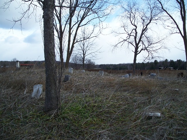
It is easier to see the cemetery in fall because it is quite
overgrown.
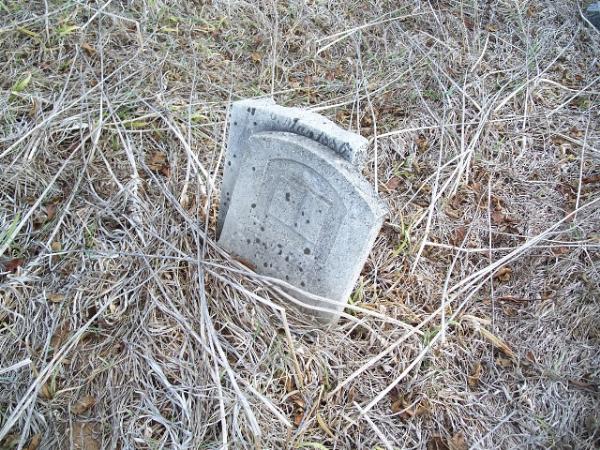
Many of the headstones are buried. Others are broken.
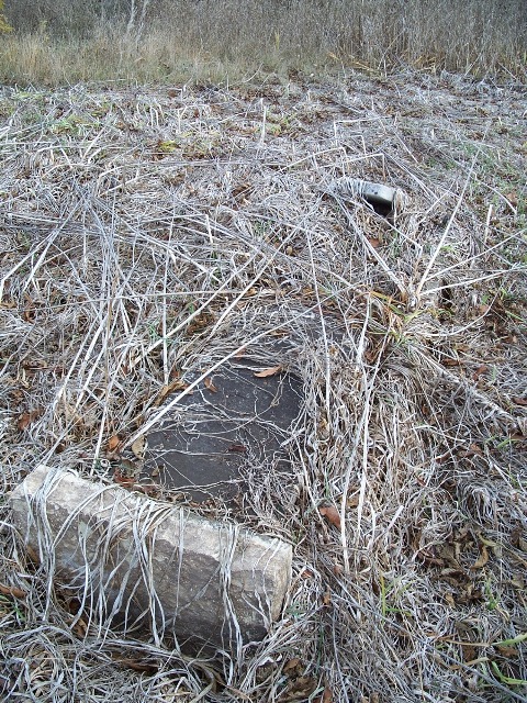
It's uncommon to find a "ledger"--a grave slab cover--but here one
is.